Project Summary: Unraveling Sediment Dynamics for Informed Urban Flood Management
Lead Researchers: Andrew Stearns, Julia Wellner; Department of Geology, College of Natural Sciences and Mathematics, University of Houston
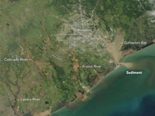
In response to the unprecedented sediment flow during Hurricane Harvey in 2017, researchers from the University of Houston's Department of Geology undertook a comprehensive analysis to understand the impact of human modifications to waterways on sediment movement. The study, published in the journal "Geology," delves into the correlation between human-induced alterations to Houston's water bodies and the immense sediment transport during the hurricane. The research aims to provide vital insights for policymakers in urban watershed management, shedding light on the repercussions of sediment accumulation for flood risks and infrastructure resilience.
Goals:
The primary goal of this research is to investigate the relationship between human modifications to waterways and sediment transport during extreme weather events, using Hurricane Harvey as a case study. The researchers seek to quantify the sediment volumes moved through Houston's waterways, understand the causes of massive sediment movement, and assess the impact on reservoir capacities. The ultimate objective is to provide policymakers with essential information for sediment management in urban watersheds, recognizing the potential cost implications and flood risk factors associated with sediment accumulation.
Methods:
The research team employed lidar (light detection and ranging), a remote sensing technology that measures ground surface elevation, to analyze sediment movement before and after Hurricane Harvey. Lidar enabled the researchers to assess elevation changes due to sediment deposition and identify areas where sediment accumulation was most significant. The study also utilized ground observations to validate and complement the lidar data.
The causes of massive sediment movement were explored, considering both natural factors such as heavy rainfall during the hurricane and human-induced modifications to waterways. The team investigated the impact of river straightening—a common engineering technique used to control water flow and reduce flooding—on sediment bypass through the streams. The researchers aimed to quantify the sediment deposited during Hurricane Harvey and its effect on the holding capacities of Addicks and Barker reservoirs.
Key Findings:
The study revealed that 27 million cubic meters of sediment moved through Houston's waterways during Hurricane Harvey, with up to five feet of sediment accumulating in the Houston Ship Channel. The economic impact of dredging the channel back to its pre-Harvey depth was approximately $350 million. The researchers found a strong correlation between stream modification and sediment bypass, particularly in areas where river straightening techniques were employed.
Houston's economically disadvantaged communities, regions near the Houston Ship Channel, and areas in the east and northeast parts of Harris County were identified as having the highest overall risk based on sediment movement. The research highlighted the compounding factors of intense rainfall and human-induced modifications, leading to substantial sediment transport.
Implications and Future Directions:
The researchers emphasized the need for policymakers to prioritize regular data collection on sediment movement in urban environments. They underscored the costliness of dredging sediment from waterways and the potential impact on flooding in the Houston area. The study serves as an initial exploration of sediment dynamics in urban settings, prompting further research to delve into underwater sediment movement and the long-term implications of urban sprawl on sediment transport.
By unraveling the complexities of sediment dynamics, the research provides a foundation for informed decision-making in urban flood management. The insights garnered from this study can guide policymakers in developing strategies to mitigate the impact of sediment accumulation during extreme weather events, enhancing the resilience of urban infrastructure to future flood risks.