HuRRI researchers develop tool to predict vulnerability to COVID-19 in Harris County
Three researchers from HuRRI have developed a planning tool to identify vulnerable portions of the population most in need of testing and support. Dr. Hanadi Rifai, a professor of civil and environmental engineering at the University of Houston, is the corresponding author for a new paper, “Assessing COVID-19 Risk, Vulnerability and Infection Prevalence in Communities.” The co-authors are Dr. Winston Liaw, a professor of health systems and population health sciences at the College of Medicine; and Dr. Amin Kiaghadi, a postdoctoral fellow working with Rifai.
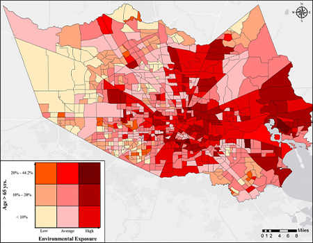
Based on preliminary analyses, specific population groups – older people, those with preexisting health conditions, people with respiratory illnesses –are more at-risk for transmission of and death from coronavirus. By using census data, the research team developed a tool to identify these populations in advance to proactively guide public resources.
For their work, the researchers developed five categories of at-risk populations:
- People with limited access to hospitals and medical care.
- People with underlying medical conditions, such as respiratory illnesses and hypertension.
- People with higher environmental exposures like air pollution and water contamination.
- People in areas vulnerable to natural disasters and flooding.
- People with specific lifestyle factors, like obesity, drinking and smoking.
Using this tool, policymakers can identify neighborhoods with a higher potential for becoming the next hot spots, efficiently match community resources with community needs, and ensure that equipment, personnel, medications, and support are available to everyone, particularly the most vulnerable and those in greatest need.
According to their paper, the researchers found that the highest-overall risk areas based on all 5 categories were located in economically disadvantaged communities and those near the Houston Ship Channel and those on the east and northeast parts of the County, while the populations with the least combined risk factors were in the western fringes of Harris County. The researchers determined that residents in the Houston Ship Channel neighborhoods, for example, are individuals with the least favorable socio-demographics, are exposed to several chemicals, and subject to flooding both from rainfall and storm surge.
According to figures from the paper based on 2018 census tract data, there are 722,357 residents of Harris County – about 17 percent of the population – in at least one risk category. Of this group, 171,403 are between 45 and 65 years old, and 76,719 are 65 years old or greater – both of which have been identified as being higher at-risk groups for death from COVID-19.
The research emphasizes the mission of HuRRI that is focused on six dimensions of resilience: Mitigation, Assessment, Prediction, Protection, Education, and Recovery (MAPPER). Similar to a natural disaster, dealing with the pandemic puts stress on the social safety net, and factors like the proximity to a hospital or a healthcare facility can effect outcomes.
Read Assessing COVID-19 Risk, Vulnerability and Infection Prevalence in Communities in medRxiv.